

Real-Time Location Systems (RTLS): A Practical Guide for Modern Operations
Every operation has the same quiet problem: things and people move, and nobody knows exactly where they are right now. A forklift sits idle while a pallet is searched for. A wheelchair or infusion pump disappears into a hallway. A technician walks the floor for ten minutes looking for the right tool. Multiplied across a shift, a site, and a year, these small delays become a serious cost.
Real-Time Location Systems (RTLS) exist to solve exactly this problem. In this guide, we explain what RTLS is, how the main technologies work, where it delivers value, and how to plan a deployment that actually pays off.
What Is an RTLS?
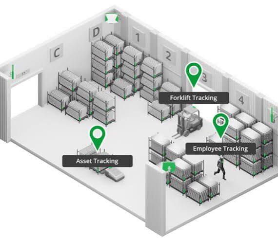
A Real-Time Location System is a combination of hardware and software that automatically identifies and tracks the location of assets, vehicles, or people, typically indoors or in areas where GPS does not work well. Small tags are attached to the things you want to track. Fixed infrastructure, such as anchors, readers, or gateways, detects those tags. Software then calculates each tag’s position and displays it on a live map, with alerts, history, and analytics layered on top.
The key word is real-time. Unlike a periodic barcode scan or a manual inventory count, RTLS keeps location data continuously up to date, so decisions are made on what is happening now rather than what happened at the last check-in.
How RTLS Works: The Core Components
Most RTLS deployments share four building blocks:
- Tags: Battery-powered devices attached to assets or worn by people. They broadcast signals that the infrastructure can detect.
- Anchors, readers, or gateways: Fixed devices installed around the facility that receive tag signals and measure them.
- Location engine and platform: Software that turns raw signal data into coordinates, zones, and events, and presents them in a dashboard.
- Integration layer: APIs that connect location data to the systems you already use, such as ERP, WMS, MES, EHR, or safety platforms.
The real value of RTLS comes from the last two. Location data on its own is interesting; location data feeding your existing workflows is transformative.
Common RTLS Technologies Compared
There is no single “best” RTLS technology. The right choice depends on the accuracy you need, your environment, your budget, and how many items you need to track.
Bluetooth Low Energy (BLE) Beacons and RSSI. The most affordable and widely available approach. Tags or beacons broadcast, and position is estimated from signal strength. It is well suited to room-level or zone-level visibility, though accuracy can vary in environments with a lot of metal, people, or interference.
Bluetooth Angle of Arrival (AoA). An evolution of BLE positioning. Instead of relying only on signal strength, multi-antenna receivers measure the angle at which a tag’s signal arrives, and combine angles from several anchors to calculate position. This generally delivers much better accuracy, often sub-meter under good conditions, while keeping the low power and low cost benefits of the Bluetooth ecosystem.
Ultra-Wideband (UWB). Uses very short radio pulses to measure distance with high precision, and can reach accuracy at the centimeter to tens-of-centimeters level. It is a strong fit for demanding use cases such as collision avoidance or precise process tracking, though infrastructure and tag costs are typically higher.
Wi-Fi. Leverages existing access points for coarse location. It is convenient where infrastructure is already in place, but is generally less precise.
RFID and passive tracking. Excellent for checkpoint-based identification, such as dock doors or gates, but it tells you that an item passed a point rather than where it is continuously.
Infrared and ultrasound. Offer very reliable room-level accuracy in controlled indoor settings, but are limited by line of sight and require dense installation.
A useful rule of thumb: match the technology to the decision you need to make. If you only need to know which room an item is in, zone-level BLE may be plenty. If you need to know which aisle, shelf, or lane, or to prevent a forklift-pedestrian collision, you will want higher precision such as AoA or UWB.

Where RTLS Delivers Value
Manufacturing
Track work-in-progress, tools, containers, and vehicles across the plant. RTLS reduces search time, reveals bottlenecks between stations, and gives planners accurate data on how materials actually flow through the line.
Warehousing and Logistics
Know where every pallet, forklift, and cart is at any moment. Real-time visibility supports faster picking, better yard and dock coordination, fewer lost or misplaced items, and more accurate inventory.
Healthcare
Hospitals use RTLS to locate mobile medical equipment, streamline patient and staff workflows, monitor patient movement in care settings, and reduce the time clinicians spend hunting for devices. That time goes back to patient care.
Safety and Security
Geofencing lets you define restricted or hazardous zones and trigger alerts when people or vehicles enter them. In an emergency, RTLS can show who is where, which speeds up evacuation checks and response.
Smart Buildings, Retail, Museums, and Venues
Understand how people move through a space, optimize layouts and space utilization, deliver indoor navigation, and personalize visitor experiences, while keeping privacy requirements in mind.

The Business Benefits
When deployed well, RTLS typically produces benefits in four areas:
- Productivity: Less time searching for assets and people, and smoother handoffs between teams.
- Asset utilization: Better visibility means you can right-size fleets and equipment pools instead of buying more “just in case.”
- Safety and compliance: Automated zone alerts, proximity warnings, and auditable movement history.
- Data for continuous improvement: Heatmaps, dwell times, and flow analysis reveal inefficiencies that are invisible to the naked eye.
Planning a Successful RTLS Deployment
Most failed RTLS projects fail before the first anchor is installed. These steps help avoid that.
- Start with a business problem, not a technology. Define the specific outcome, such as reducing equipment search time or eliminating near-misses, and how you will measure it.
- Define your accuracy and update-rate requirements. Room-level, meter-level, and sub-meter systems differ greatly in cost. Choose what the use case truly needs.
- Survey the environment. Metal racking, concrete, liquids, and moving machinery all affect radio performance. A site survey and pilot will prevent surprises.
- Think about the tag. Size, battery life, form factor, ruggedness, and how it attaches to the asset or badge all matter in daily use.
- Plan integrations early. Decide which systems should consume location data and which events should trigger actions.
- Pilot, measure, then scale. A focused pilot in one area proves the value, builds internal support, and informs the full rollout.
- Address privacy and change management. When tracking people, be transparent about what is tracked and why, and comply with local regulations and policies.
Trends Shaping RTLS
- Convergence on Bluetooth: Bluetooth’s large ecosystem of chips, tags, and developers is lowering cost and speeding up adoption of higher-accuracy methods such as AoA.
- Open APIs and platforms: Buyers increasingly expect location data to flow freely into their existing software.
- Hybrid systems: Many sites combine technologies, for example BLE for broad coverage and UWB for high-precision zones.
- AI-driven analytics: Location history feeds predictive insights, such as forecasting congestion or optimizing routes.

Key Takeaways
RTLS turns “where is it?” from a daily frustration into an instant answer, and then into a source of operational intelligence. The most successful projects begin with a clear problem, pick the technology that fits the required accuracy, and integrate location data into the workflows people already use.
Talk to Axlesystems About RTLS
Whether you are exploring RTLS for the first time or looking to improve an existing deployment, Axlesys can help you assess your requirements, select the right approach, and plan a pilot that proves value quickly. Contact us at axlesys.com to start the conversation.